Almont, CO Weather from Weather Underground

Monday, November 21, 2011

Tucson

Well did our managers meeting for the Christmas Tree Lot at a Phoenix hotel.  Got to see these balloons lift off on our way.

Friday, we spend the whole day learning how to run a Christmas Tree Lot.  We have to be at the Lot on Saturday to start setting up.  So, we head on down the road to Tucson.

I wonder how fast we should take this turn 
Occupy Tucson 


We originally were to be in Phoenix then we were told on Broadway in Tucson, this is the lot but it wasn't set up.  I guess the deal fell thru on this lot and we were moved to the Pantano Lot 

Pantano Lot in front of Sam Levitz Furniture  

At least it has a view of the Catalina Mountains 

Then the first load of Trees arrives 11/21

Get em in and get em watered.


The extras get left on the ground out back under shade tarps.  They need to be watered 3-4 times a day.


Trees need to have holes drilled in the trunks for the stands, stood up, placed in the tent, the netting cut off and the stands filled with water.  All of our trees will be sold displayed in Stands so the people can see exactly what they are getting, they are also showered with water 3-4 times a day to keep them moist, unlike the Big Box stores that just put them bundled in a bin without water for weeks on end.  We have Nobles, Nordmanns, Grand Firs, Fraser Firs and Douglas Firs.

We will open Thanksgiving Day and sell until Christmas Eve.  Lots of work to do and a tent to decorate as well.


Thursday, November 17, 2011

Picacho Peak - Hike to the summit - don't forget your gloves!


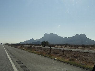
While at Tortilla Flat we were told we should hike to the top of Picacho Peak and to be sure to bring gloves as part of the hike requires holding onto cables.  Here it is off in the distance.  Picacho peak is believed to be 22 Million years old - 4 times older than the Grand Canyon

Let the games begin.  It is a 3 mile round trip hike.  Picacho Peak has been use as a navigational landmark for hundreds of years, was the site of Arizona's only Civil War battle, is a geographic spectacle, and it has petroglyphs from prehistoric Hohokams - but we didn't see any.

Getting closer - figure we'll get to that next level turn right and then turn and go up to the summit. 

We get up to the Saddle - the view is great.  But where is the trail up?

Gary says he thinks it's this way - but wait a minute that goes down . .


and down . . . 

and down. . . .


and down.  Apparently after the Saddle the fun begins.

This is where the cables come into play.  In 1932 a 10' light beacon was installed at the peak for air traffic navigation.  Hunter trail was built the Civil Conservation Corp to facilitate servicing the beacon.  It was removed in 1965.

It's a fairly strenuous hike in spots. 

Then what goes down goes back up!

You can barely see the cables from here. 

Here's a closer view of a group going up.

Here's a volunteer that passed us earlier working on tightening the cables. 

Gary the Cable Guy


Made it! 

A great recommendation and a great hike!

Till Later,

Meanwhile, we keep on Trek'n

Melissa & Gary

Sunday, November 13, 2011

Goldfield Ghostown - Gateway to the Apache Trail

Back in the 1890's Goldfield boasted 3 saloons, a boarding house, general store, blacksmith shop, brewery, meat market and a school house. Just when it looked like the town would outgrow Mesa, the vein faulted, the grade of ore dropped and the town died a slow painful death.  It is now a tourist attraction with shops and restaurants and a train that circles the Town.  There are gunfights on the weekends.


Had a really good burger at the Saloon. 

The Train and horseback riding was available. 

The residents are very friendly 


Till Later,

Meanwhile, we keep on Trek'n

Melissa and Gary

Saturday, November 12, 2011

Apache Trail - A long and winding road . . .

Okay, time for that drive down 88 - the Apache Trail, a winding paved road that becomes a 1 lane dirt road.  We had done this one in our 1st RV a 23' C Class back in 2000, can't believe we actually did that!

Always wondering what's going to be around that next corner!

A look off to the side shows the road ahead


We are down to water level now.

What's that up ahead?

Damn!  It's the Roosevelt Dam! 

The first stone was laid in place in September 1906.  It took 5 years to build.  The blocks of stone were carved out of the Canyon Walls.  It was finished in February 1911 and was the largest stone dam in the world. 


The Bridge built from 1987-1990 to relocate traffic off the top of Roosevelt Dam.  It was named one of the top 12 bridges in the Nation.  The road on the bridge is arched because if they had made it level, drivers would have the perception that it was sagging, not a good sensation at 150 feet over water. 

Only a 45 mile  drive but at 15 mph it took most of the day, time to head back 

As I said, its a long and winding road! 

Thought you might like to experience a bit of it!  Imagine doing this in an RV


Till Later,

Meanwhile, we keep on Trek'n

Melissa & Gary

Friday, November 11, 2011

Tortilla Flat, AZ - Population 6

We leave Lost Dutchman and head to Tortilla Flat - population 6

We pass through Canyon Lake on the way


Sure wish we had that Amphicar! 

We arrive at Tortilla Flat  

and turn into the campground and find a nice site. 

It's all about the view!   Bet it's even better at the top of that hill.

Lets find out


Birds eye view of Tortilla Flat


A good place to just sit and contemplate 

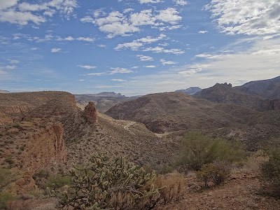
Apache Trail down below 

Looks like Canyon Lake is just over the hill 

Worked up an appetite so we head  back down to Tortilla Flat for lunch.

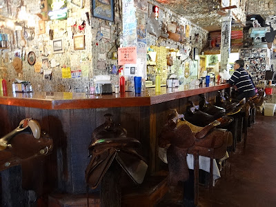
Inside the Bar the walls and ceilings are covered with $1 bills, when we were here in 2000 there was $35,000, now there is $200,000.  The bar stools are saddles - not very comfy but fun.

And they had fun with the ladies room 

The food was great, time to rest up for our trip down Apache Trail tomorrow!


Till Later,

Meanwhile, we keep on Trek'n

Melissa and Gary